
August 24, 2016 in New Caledonia
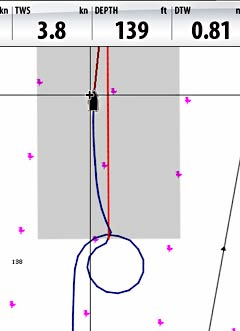
If you ever see us out on the water, doing donuts, there are at least two possible reasons:
1. We started our sundowner at sunrise, or
2. We’re calibrating our compass. This was the case today.
Why?
OK, good question. I think it’s necessary because of the change in magnetic deviation as you change latitudes. There’s quite a difference between New Zealand (about 20° declination) and New Caledonia (about 12.5° declination).
Yea, but what difference does that make?
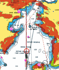
For us, the most obvious difference is in how the radar images align with the chart. Notice on the before and after animation how much the alignment changes.
I used to think this was just some kind of drifting alignment issue with the chartplotter or radar. I’d change the settings in the radar setup to adjust for this. The nice folks at Navico explained that it was probably due to magnetic variation as we traveled north and south each season.
Now, after each leap up or down the globe, we do a donut to calibrate the electronic fluxgate compass.


