Posted February 10, 2024
about September 21, 2022
We woke up to another somewhat foggy morning, but I knew it would soon clear into a sunny day. The anchorage had a slight roll but nothing significant. In areas like this, sheltered behind a barrier reef, high tide brings more water over the reef, resulting in increased movement. Sometimes the difference is dramatic; other times it’s subtle enough not to matter. Today was the latter, making for an overall lovely morning.
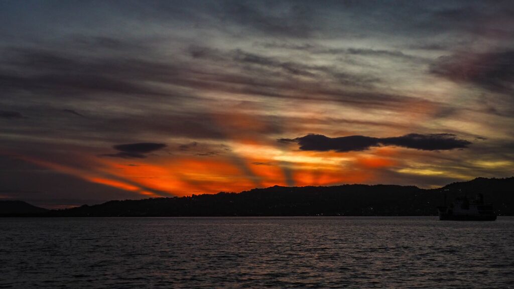
Today we planned to sail on to the next group of islands, the Lindeman Group, bypassing the Anchor Islands which didn’t seem particularly interesting. At this point we weren’t feeling rushed, but we wanted to keep up our steady northward pace. The destination was Thomas Island, lying about seven miles to the north. With intriguing anchorages on both its northern and southern shores, I wondered if it might be worthwhile to visit both sides. Below, Thomas Island . . .
Reviewing the weather forecasts proved frustrating, with breezes shifting from north to northeasterly. This meant we needed an anchorage offering shelter from both directions. My chosen anchorage would be fine for northerlies, but Rich was concerned about easterlies, specifically an easterly swell. I proposed that we could give the spot a try, and if it wasn’t good, we could move.
I checked the map for a backup location and realized the perfect spot for today’s conditions would be right here at Goldsmith! When I shared this with Rich, he made a peculiar comment, something like “only if you want a body on the boat.” Huh? He elaborated that he’d have to kill himself if we stayed here. Huh? I should have paid more attention to this, but instead I let it pass.
In human relationships, odd comments that don’t fit in the other’s perception of the big picture can be like little ticking bombs, warning of an explosion to come. Yet their oddness is the very thing that makes them so easy to overlook.
So, we brought up the anchor and headed north. Below, a map of the area:
Today was another motoring trip. One nice thing: the current flowed only half a knot here, much less drastic than it had been on our previous trips between islands. We’d been managing to go with it so far, but if the time came we had to go against it, it would be doable. The breeze was light, and we had our cockpit water misters on for the trip.
I was studying Thomas Island’s south side through the binoculars when the bomb went off. I don’t remember what triggered it, but suddenly Rich was exclaiming how unhappy he was with our cruise since leaving Gladstone. He didn’t like the daily short hops, the crowded, rolly anchorages, the poor water quality, and the lack of things to do. Huh? Gazing at him, I wondered if an alternate version of Rich had teleported here from a parallel universe, starkly different from the one where I’d been living.
Obviously we needed to have a discussion, difficult to do when both of us were now upset. I could counter all his issues, but that would be pointless. The bottom line was his unhappiness with our present circumstances, likely stemming from a combination of issues.
One thing was that for Rich, the negatives were weighing more heavily than the positives. My attention was on the nice places: enchanting Middle Percy, delightful Keswick, and picturesque Goldsmith. Meanwhile the less appealing spots–harrowing Hexham, menacing Curlew, and ominous Brampton island–cast a longer shadow for Rich. He was ready to move on from this region, wanting to bypass the Whitsunday Islands, now just a few hours ahead of us. I protested that skipping the Whitsundays would be like visiting Anaheim and deciding to skip Disneyland because you didn’t like the wax museum along the way!
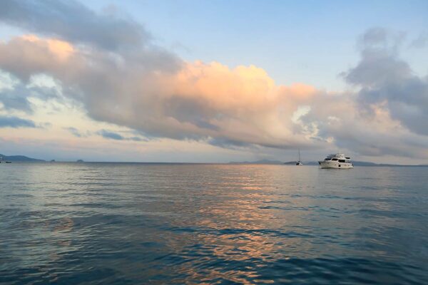
We hashed things out. I proposed we could skip the entire Lindeman Island group and head directly for the Whitsundays. Once there, we could cruise through that area as quickly as possible. Rich agreed, and we proceeded to bypass Thomas Island. Below, I did manage to get photos of the island’s south side anchorages . . .
After a time, Rich softened and said he’d be willing stop at Shaw Island, just ahead of us, for the night. I set aside my own temporary apathy, spurred by a bout of grumpiness, to grab the opportunity and began scouting the best anchorage option.
Meanwhile I thought about our situation. A while back, I’d realized Rich wasn’t exactly enamored with Queensland coastal cruising and had taken care to pick only the best spots. I thought I’d accomplished this, but I hadn’t been “reading the room” and needed to do better.
Since the Whitsunday Islands are considered the cream of the crop for this area, they should be reliably nicer than the islands we’d visited so far. However, I’d have to be even more discerning in my selection of anchorages, bypassing places that were merely “nice.” The challenge would be greater since I’d be depending on guidebook opinions as, astonishingly, there was no cell service/internet access in these islands.
I was hesitant to share this but decided it’s pertinent. This sort of scenario can be an unavoidable part of the cruising life. It’s common for some to feel a deep connection with certain locales, while others might experience an immediate aversion to a place or individual without any clear rationale.
For those not sailing solo, navigating this dynamic is likely inevitable unless one partner completely stifles themselves in favor of the more dominant person, which sadly I’ve witnessed out here, or if one person assumes complete control, disregarding the preferences of their companions. (This last dynamic is most often seen between parents and children or, quite naturally, between older captains and their younger crew.)
The best advice I can give is to try to keep the lines of communication open, but it’s easier said than done. Coming up next, Shaw Island in the Lindeman Islands. –Cyndi